The Intercept Method » Plotting
For our example, Capella's computed altitude (Hc) and azimuth (Zn) at DR (AP) and time of observation are: Hc = 29° 28.8' and Zn = 051.5°. Chief Sheedy marks azimuth line, uses Ho-Mo-To to determine the intercept, and plots the LOP.
To apply the intercept method, we first plot the azimuth line through the DR position. The azimuth is the direction toward (or away) from the star's geographic position.
To determine if our LOP is toward the geographic position or away from it, we use the moniker "Ho-Mo-To" (pronounced "Hoe - Moe - Toe"). This means observed altitude (Ho) More (Mo) Toward (To). If the Ho is more than the Hc, then we plot the intercept toward the GP, that is, toward the direction of the star. Ho-Mo-To is an important mnemonic to memorize.
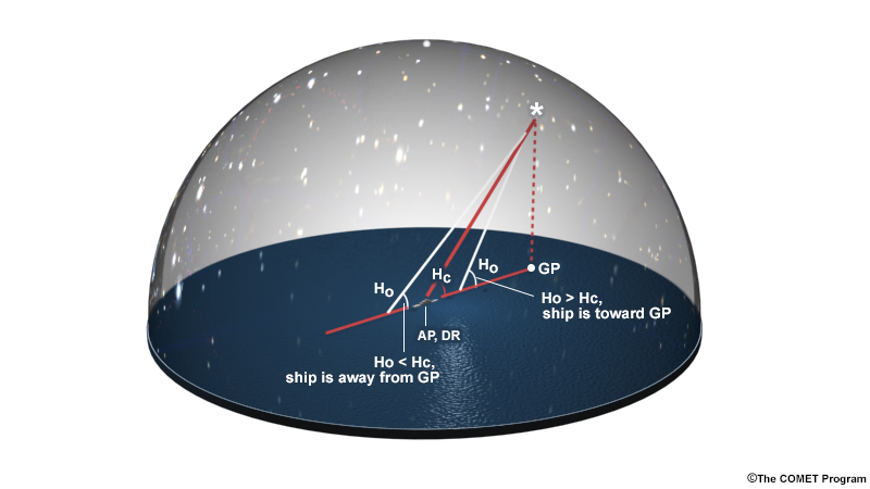
Conversely, if Ho is less than Hc, our intercept is away from the GP, that is, away from the star.
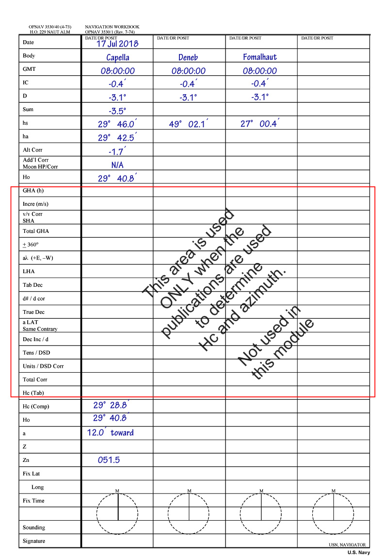
In our example, Ho is more than Hc, so our intercept is 12.0 arcminutes toward the GP. Chief Sheedy demonstrates this process to plot a line of position for Capella.
Chief Sheedy: We now have our computed altitude, as well as the azimuth, from the U.S. Naval Observatory website. We’re going to put it on the strip form. Computed altitude was 29 degrees 28 decimal 8. We bring down our observed altitude 29 degrees 40 decimal 8. The difference between the two is 12 minutes. Since the height observed is more than the computed altitude, it’s going to be “toward”—remember the phrase Ho-Mo-To. The azimuth from the U.S. Naval Observatory website is 051.5.
We will now plot on the Universal Plotting sheet. The Assumed Position is 31 degrees 25 minutes. The assumed longitude is 054 degrees 12 minutes West. That is what I plotted in the example of setting up the Universal Plotting Sheet. From the Assumed Position we’ll then draw out our bearing to the geographic position, or azimuth to Capella, which was 051 decimal 5 given to us by the U.S. Naval Observatory website. So we’ve got 051 decimal 5…pointed this way, we draw an arrow, labeled GP for geographic position.
Our line of position is 12 miles towards the geographic position. I mark 12 minutes of latitude which is 12 nautical miles. Now you may think this line to the geographic position, or azimuth, is our line of position, but it actually isn’t. It’s a perpendicular line brought down to 12 minutes towards Capella. This is our line of position and I will label it properly. The time was 0800. Underneath the line I’ll put Capella. Our actual position falls somewhere on this line of position.

Remember, our position is somewhere on the line of position we’ve marked on the plot.
In order to find out where our position actually is, we need to take another sextant measurement of a different star in a different direction of the sky. Performing the sight reduction in the exact same way, we will get another LOP that crosses the first one. Our location is at the intersection. In reality, we want at least three LOPs, which are parts of larger circles of position, that should all cross at about the same spot. How closely they intersect gives us an indication of the accuracy of our fix.