The following tables from COMNAVTMETOCCOMINST 3144.1.E are accessible on this page (click title to jump to table):
Table II-3-10 Sky Cover Contractions
| Reportable Contraction |
Meaning |
Summation Amount of Layer |
| SKC or CLR |
Clear |
0 |
| FEW |
Few |
1/8 - 2/8 |
| SCT |
Scattered |
3/8 - 4/8 |
| BKN |
Broken |
5/8 - 7/8 |
| OVC |
OVC |
8/8 |
| VV |
Vertical Visibility |
8/8 |
Table II-5-4 Estimating the Intensity of Precipitation based on Rate-of-Fall
| Light |
A trace to 0.10 inch (2.5 mm) per hour; a maximum of 0.01 inch (0.3 mm) in 6 minutes |
| Moderate |
0.11 inch to 0.30 inch (2.6 to 7.6 mm) per hour; more than 0.01 inch (0.3 mm) to 0.03 inch (0.8 mm) in 6 minutes |
| Heavy |
More than 0.30 inch (7.6 mm) per hour; more than 0.03 inch (0.8 mm) in 6 minutes |
Table II-5-5 Estimating the Intensity of Rain
| Light |
A trace of more up to a condition in which individual drops are easily seen; slight spray is observed over decks; puddles form slowly; sound ranges from a slow pattering to a gentle swishing; steady small streams may flow off decks. |
| Moderate |
Individual drops are not clearly identifiable; spray is observable just above decks and other surfaces; puddles form rapidly; sound ranges from a swishing sound to a gentle roar. |
| Heavy |
Rain seemingly falls in sheets; individual drops are identifiable; heavy spray to a height of several inches is observed over hard surfaces; visibility is greatly reduced; sound resembles the roll of drums or a distant roar. |
Table II-5-6 Intensity of Drizzle, Snow Grains, Snow Pellets, or Snow
| Light |
Visibility equal to or greater than 5/8 statute mile, 0.55 nautical mile, or 1000 meters |
| Moderate |
Visibility 5/16 to 5/8 statute mile, 0.25 to 0.55 nautical mile, or 500 to 1000 meters |
| Heavy |
Visibility equal to or less than 1/4 statute mile, 0.2 nautical mile, or 400 meters |
Table II-5-7 Estimating the Intensity of Ice Pellets
| Light |
Scattered pellets that do not completely cover an exposed surface regardless of duration. Visibility is not affected. |
| Moderate |
Slow accumulation. Visibility reduced to less than 7 nautical miles or 9000 meters. |
| Heavy |
Rapid accumulation. Visibility reduced to less than 3 nautical miles or 4000 meters. |
Table II-5-8 Estimating the Intensity of Drizzle on Rate-of-Fall Basis
| Light |
A trace to 0.01 inch (0.3 mm) per hour |
| Moderate |
More than 0.01 inch (0.3 mm) to 0.02 inch (0.5 mm) per hour |
| Heavy |
More than 0.02 inch (0.5 mm) per hour |
| Note: This table is used to estimate the intensity of drizzle when it is not occurring alone. However, in no case should the intensity be higher than that which would be determined using the visibility criteria in Table II-5-5. |
Table II-6-2 Standard Additive Reduction Constants
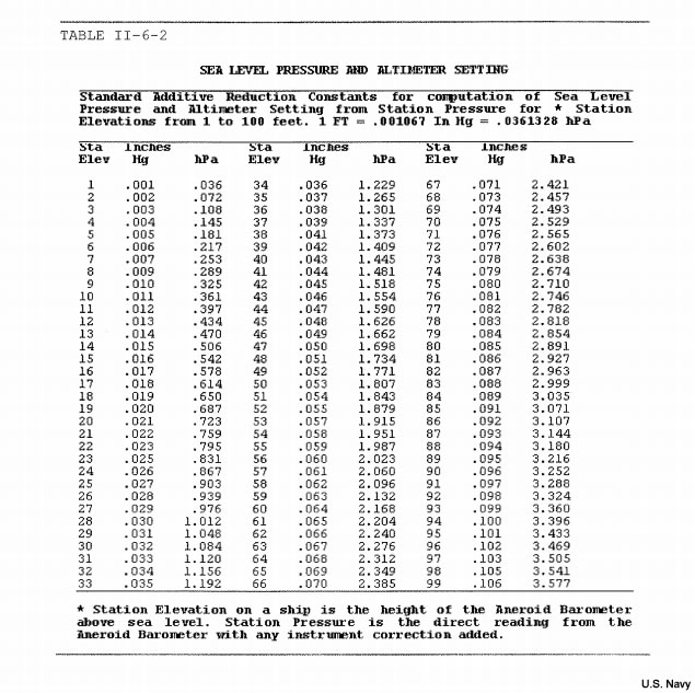
|
Table III-3-2 Height above Ground of the Base of the Lowest Cloud Layer
| Code figure |
Feet |
Meters |
| 0 |
00 to 99 |
00 to 49 |
| 1 |
100 to 299 |
50 to 99 |
| 2 |
300 to 699 |
100 to 199 |
| 3 |
700 to 999 |
200 to 299 |
| 4 |
1000 to 1999 |
300 to 599 |
| 5 |
2000 to 3299 |
600 to 999 |
| 6 |
3300 to 489 |
1000 to 1499 |
| 7 |
4900 to 6499 |
1500 to 1999 |
| 8 |
6500 to 7999 |
2000 to 2499 |
| 9 |
8000 or above, or no clouds |
2500 or above, or no clouds |
| / |
Height not known |
Height not known |
Table III-3-3 Horizontal visibility at Surface
| Code figure |
Nautical miles |
| 90 |
Less than 1/16 |
| 91 |
1/16 |
| 92 |
1/8 |
| 93 |
1/4 |
| 94 |
1/2 |
| 95 |
1 or 1 1/2 |
| 96 |
2, 2 1/2, or 3 |
| 97 |
5, 6, 7, or 8 |
| 98 |
9 or 10 |
| 99 |
Not reported |
Table III-3-4: Total Cloud Cover
| Code figure |
Tenths |
Oktas (Eighths) |
| 0 |
0 |
0 (SKC) |
| 1 |
1/10 or less, but not 0 |
1 okta or less, but not 0 |
| 2 |
2/10 and 3/10 |
2 oktas (FEW) |
| 3 |
4/10 |
3 oktas |
| 4 |
5/10 |
4 oktas |
| 5 |
6/10 |
5 oktas |
| 6 |
7/10 and 8/10 |
6 oktas |
| 7 |
9/10 or more, but not 10/10 |
7 oktas or more, but not 8 |
| 8 |
10/10 |
8 oktas |
| 9 |
sky obscured by fog and/or other meteorological phenomena |
| / |
Cloud cover is indiscernible for reasons other than fog or other meteorological phenomena, or observation is not made |
Table III-3-5: Characteristic of Pressure Tendency
| Code figure |
Column title |
| 0 |
Pressure higher now than three hours ago
Increasing, then decreasing; atmospheric pressure
the same or higher than three hours ago. |
| 1 |
Increasing, then steady; or increasing then
increasing more slowly. |
| 2 |
Increasing, steadily or unsteadily. |
| 3 |
Decreasing or steady, then increasing; or
increasing, then increasing more rapidly. |
| 4 |
Steady; pressure the same as three hours ago. |
| 5 |
Decreasing, then increasing; pressure the same or
lower than three hours ago. Pressure lower now than three hours ago. |
| 6 |
Decreasing, then steady; or decreasing, then
decreasing more slowly. |
| 7 |
Decreasing, steadily or unsteadily. |
| 8 |
Steady or increasing, then decreasing; or
decreasing, then decreasing more rapidly. |
Table III-3-7 Past Weather Code Specifications in Order of Priority
| Code figure |
Weather |
| 9 |
Thunderstorm(s) with or without precipitation |
| 8 |
Shower(s) |
| 7 |
Snow, or rain and snow mixed |
| 6 |
Rain |
| 5 |
Drizzle |
| 4 |
Fog or ice fog, or thick haze |
| 3 |
Sandstorm, duststorm, or blowing snow |
| 2 |
Cloud covering more than 1/2 of the sky throughout the
appropriate period |
| 1 |
Cloud covering more than 1/2 of the sky during part of the appropriate period and covering 1/2 or less during part of the period |
| 0 |
Cloud covering 1/2 or less of the sky throughout the appropriate period |
Table III-3-8 Coding of CL Clouds
| Priority |
Code |
CL Cloud Present |
| 1st |
9 |
Cumulonimbus present, with or without other CL clouds: The upper part of at least one of the CB clouds present is clearly fibrous or striated. By convention, code figure 9 is used for CBMAM and for those cases in which lightning, thunder or hail indicates the presence of CB but the top is hidden by other clouds.
|
| 3 |
The upper part of NONE of the CB clouds present is clearly fibrous, striate, or in the form of an anvil. |
| 2nd |
4 |
No Cumulonimbus present: SC formed by the spreading out of CU is present |
| 3rd |
8 |
Code figure 4 is not applicable, and CU and SC (not formed by the spreading out of CU) with bases at different levels are present. |
| 2 |
Code figures 4 and 8 are not applicable, and TCU or CU of moderate or strong vertical extent are present. |
| 4th |
1 |
No Cumulonimbus present and CL code figures 4, 8 and 2 are not applicable: Predominant type of low cloud is CU with little vertical extent and seemingly flattened, or ragged CU other than bad weather, or both |
| 5 |
Predominant type of low cloud is SC other than that formed by the spreading or flattening of CU |
| 6 |
Predominant type of low cloud is ST in a relatively continuous layer, or ragged shreds (other than of bad weather), or both |
| 7 |
Predominant type of low cloud is STFRA of bad weather or CUFRA of bad weather, or both (pannus); usually below AS or NS. |
Table III-3-9 Coding of CM Clouds
| Priority |
Code |
CL Cloud Present |
| 1st |
9 |
Altocumulus present (with or without AS or NS): AC of a chaotic sky is present (generally at several levels), with or without AS or NS. |
| 8 |
Code figure 9 is not applicable; and, AC with sproutings in the form of turrets or battlements or AC having the appearance of small cumuliform tufts is present, with or without AS or NS. |
| 2nd |
7 |
Altocumulus present (with AS or NS): Code figures 9 and 8 are not applicable; and, AC or NS is present together with AC. |
| 3rd |
6 |
Altocumulus present (with or without AS or NS): Preceding code figures are not applicable; and AC present is formed by the spreading or flattening of CU or CB. |
| 5 |
Preceding code figures are not applicable; and, AC present is progressively invading the sky. |
| 4 |
Preceding code figures are not applicable; and, AC present is in the form of semitransparent patches (often almond-shaped, fish-shaped or lenticular), continuously changing in appearance and occurring at one or more levels. |
| 7 |
Preceding code figures are not applicable; and, AC is present at two or more levels, not progressively invading the sky. |
| 7 |
Preceding code figures are not applicable; and predominantly opaque AC is present at one level, not progressively invading the sky. |
| 3 |
Preceding code figures are not applcable; and, predominantly semitransparent or transparent AC is present at one level, not progressively invading the sky. |
| 4th |
2 |
No Altocumulus present: NS or predominantly opaque AS is present |
| 1 |
No NS, and AS present is predominantly semitransparent or transparent |
Table III-3-10 Coding of CH Clouds
| Priority |
Code |
CL Cloud Present |
| 1st |
9 |
Cirrocumulus (Alone or Predominant): CC is present or alone, or CC amount is predominant when compared with combined sky cover of any CI and CS present |
| 2nd |
7 |
Cirrostratus (with or without CI or CC and code figure 9 is not applicable): CS covers the entire sky (10/10 or 8/8 sky cover). |
| 8 |
CS does not cover the whole sky and is not invading the celestial dome. |
| 6 |
CS (or CS and CI) is progressively invading the sky and the continuous veil extends more than 45 degrees above the local horizon but does not cover the while sky. |
| 5 |
CS (or CS and CI) is progressively invading the sky and the continuous veil does not extend more than 45 degrees above the local horizon. |
| 3rd |
4 |
Cirrus (code figure 9 not applicable and no CS present): CI (hooks, filaments or strands) progressively invading the sky and generally growing denser. |
| 3 |
Code figure 4 is not applicable; and dense CI present (often in the form of an anvil originated from Cumulonimbus). |
| 2 |
Code figure 4 and 3 are not applicable; and CI present is predominantly dense patches or with sproutings in the form of small tufts or battlements. |
| 1 |
Code figure 4, 3, and 2 are not applicable; and CI present is predominantly in the form of thin filaments, strands or hooks (not progressively invading the sky). |
Table III-4-3 ss—Sign and Type of Sea Surface Temperature
| Code |
Meaning |
| 0 |
positive or zero intake measurement |
| 1 |
negative intake measurement |
| 2 |
positive or zero bucket measurement |
| 3 |
negative bucket measurement |
| 4 |
positive or zero hull contact sensor |
| 5 |
negative hull contact sensor |
| 6 |
positive or zero neither intake, bucket or hull |
| 7 |
negative neither intake, bucket or hull |
Table III-4-4 Ci—Wave Height in Half Meters for Synoptic Encoding
| Code figure |
Height in feet |
Code figure |
Height in feet |
| 00 |
0 (calm) |
16 |
25 or 26 |
| 01 |
1 or 2 |
17 |
27 or 28 |
| 02 |
3 or 4 |
18 |
29 |
| 03 |
5 |
19 |
30 or 31 |
| 04 |
6 or 7 |
20 |
32 |
| 05 |
8 |
21 |
33 or 34 |
| 06 |
9 or 10 |
22 |
35 or 36 |
| 07 |
11 or 12 |
23 |
37 |
| 08 |
13 |
24 |
38 or 39 |
| 09 |
14 or 15 |
25 |
40 |
| 10 |
16 |
26 |
41 or 42 |
| 11 |
17 or 18 |
27 |
43 or 44 |
| 12 |
19 or 20 |
28 |
45 |
| 13 |
21 |
29 |
46 or 47 |
| 14 |
22 or 23 |
30 |
48 |
| 15 |
24 |
31 |
49 or 50 |
Table III-4-5 Is—Source of Ice Accretion
| Code figure |
Meaning |
| 1 |
Icing from ocean spray |
| 2 |
Icing from fog |
| 3 |
Icing from spray and fog |
| 4 |
Icing from rain |
| 5 |
Icing from spray and rain |
Table III-4-6 EsEs—Thickness of Ice Accretion
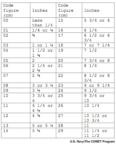
|
Table III-4-7 Rs—Rate of Ice Accretion
| Code figure |
Meaning |
| 0 |
Ice not building up |
| 1 |
Ice building up slowly |
| 2 |
Ice building up rapidly |
| 3 |
Ice melting or breaking up slowly |
| 4 |
Ice melting or breaking up rapidly |
Table III-4-8 sw—Sign and Type of Wet Bulb Temperature
| Code figure |
Description |
| 0 |
positive or zero measured |
| 1 |
negative measured |
| 2 |
iced bulb measured |
| 3-4 not used |
|
| 5 |
positive or zero computed |
| 6 |
negative computed |
| 7 |
iced bulb computed |
Table III-4-9 Ci—Concentration of Arrangement of Sea Ice
| |
Ci -- Concentration or Arrangement of Sea Ice in Priority Order |
| |
NOTE: When reporting code figures 9 through 6:
- The ship is in ice or within 0.5 NM of an ice edge, and
- The sea ice is not uniform in the observation area
|
| 9 |
Fast ice with close or very close pack ice to seaward of the ice boundary |
| 8 |
Fast ice with open water, very open or open pack ice to seaward of the ice |
| 7 |
Strips and patches of close or very close pack ice with areas of lesser concentration between |
| 6 |
Strips and patches of pack ice with open water between |
| |
NOTE: When reporting code figures 5 through 2:
- The ship is in ice or within 0.5 NM of an ice edge, and
- The sea ice is uniform in the ice area
|
| 5 |
9/10 or more, but not 10/10 (7/8 to less than 8/8), very close pack ice |
| 4 |
7/10 to 8/10 (6/8 to less than 7/8), close pack ice |
| 3 |
4/10 to 6/10 (3/8 to less than 6/8), open pack ice |
| 2 |
Sea ice present in concentrations less than 3/10 (3/8), open water or very open pack ice
|
| |
NOTE: Remaining codes follow: |
| 1 |
Ship in open lead more than 1.0 NM, (also code Di = 0) or, ship in fast ice with boundary beyond limit of visibility (also code Di = 9) |
| 0 |
No sea ice in sight |
| / |
Unable to report, because of darkness, lack of visibility, or because ship is more than 0.5 NM from ice edge |
Table III-4-10 Si Stage of Development of Sea Ice
| |
Si -- Stage of development of Sea Ice in Priority Order |
| 9 |
Predominantly old ice |
| 8 |
Predominantly medium and thick first-year ice with some old ice (usually more than 2 meters thick) |
| 7 |
All medium and thick first year ice |
| 6 |
Predominantly medium first-year ice (70 to 120cm thick) and thick first year ice (greater than 120cm thick) with some thinner (young) first year ice |
| 5 |
All thin first-year ice (30 to 70cm thick) |
| 4 |
Predominantly thin first-year ice with some new and/or young ice |
| 3 |
Predominantly new and/or young ice with some first-year ice |
| 2 |
Young ice (grey ice, grey-white ice), 10 to 30cm thick |
| 1 |
Nilas or ice rind, less than lOcm thick |
| 0 |
New ice only (frazil ice, grease ice, slush, shuga) |
| / |
Unable to report, because of darkness, low visibility, only ice of land origin is visible, or because ship is more than 0.5 nautical miles away from ice edge |
Table III-4-11 bi Ice of Land Origin
| |
bi -- Ice of land origin in Priority Order |
| 9 |
More than 20 icebergs with growlers and bergy bits, a major hazard to navigation |
| 8 |
11-20 icebergs with growlers and bergy bits |
| 7 |
6-10 icebergs with growlers and bergy bits |
| 6 |
1-5 icebergs with growlers and bergy bits |
| 5 |
More than 10 growlers and bergy bits, no icebergs |
| 4 |
Up to and including 10 growlers and bergy bits, no icebergs |
| 3 |
11-20 icebergs, no growlers or bergy bits |
| 2 |
6-10 icebergs, no growlers or bergy bits |
| 1 |
1-5 icebergs, no growlers or bergy bits |
| 0 |
No ice of land origin |
| / |
Unable to report, because of darkness, low visibility, or because only sea ice is visible |
Table III-4-12 Di True Bearing of Principal Ice Edge
| |
Di -- True Bearing of Principal Ice Edge |
| 0 |
Ship in shore or flaw lead |
| 1 |
Principal ice edge towards NE |
| 2 |
Principal ice edge towards E |
| 3 |
Principal ice edge towards SE |
| 4 |
Principal ice edge towards S |
| 5 |
Principal ice edge towards SW |
| 6 |
Principal ice edge towards W |
| 7 |
Principal ice edge towards NW |
| 8 |
Principal ice edge towards N |
| 9 |
Not determined (ship in ice) |
| / |
Unable to report, because of darkness, lack of visibility, or because only ice of land origin is visible |
Table III-4-13 bi Present Ice Situation and Trend
| |
zi -- Present Ice Situation and Trend of Conditions over Preceding 3 hours in Priority Order |
| 9 |
Ship beset |
| 8 |
Ice under moderate or severe pressure |
| 7 |
Ice under slight pressure |
| 6 |
Ice forming and floes freezing together |
|
Code figures 5 through 1 are used for all other situations when the ship is in ice. |
| 5 |
Ship in ice difficult to penetrate, conditions not changing |
| 4 |
Ship in ice difficult to penetrate, conditions improving |
| 3 |
Ship in easily penetrable ice, conditions worsening |
| 2 |
Ship in easily penetrable ice, conditions not changing |
| 1 |
Ship in easily penetrable ice, conditions improving |
| 0 |
Ship in open water with floating ice in sight |
| / |
Unable to report because of darkness or lack of visibility |