Table of Contents
Arctic Climate
Arctic ClimateInfluences on Arctic Weather
Arctic weather is influenced by several factors, many of which are not found at lower latitudes.
- Continuous daylight at the height of summer followed by continuous darkness in the depths of winter. Combined with the sun's low height above the horizon, this leads to heavy radiative heat loss through much of the year;
- The presence of snow and sea ice on the surface for much of the year reflects much of the incoming shortwave solar radiation;
- Sea ice cover on the ocean limits the amount of available moisture that can be picked up and carried by the atmosphere. Cool surface air temperatures further limit the humidity; and
- There are relatively few mountains at high latitudes to obstruct atmospheric flow between midlatitudes and the Arctic. The areas of highest relief are Greenland, Ellesmere and Baffin Islands in Canada, the Brooks and Alaska ranges in Alaska, and the mountains of Scandinavia. Thus, weather is dominated by synoptic systems rather than mesoscale features.
Arctic ClimateSynoptic Patterns
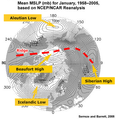
The synoptic picture of the Arctic is dominated by only a few features. In winter we find lows over the North Atlantic (Icelandic Low) and North Pacific (Aleutian Low). These lows are separated by a ridge composed of the intense Siberian High and the weaker Beaufort and North American Highs. It is important to understand that the Aleutian and Icelandic Lows are climatological features reflecting the high frequency of lows in the area. On a day-to-day basis these lows can be located anywhere across a broad region. The Siberian High is an intense, shallow, cold anticyclone that forms in response to radiational cooling over eastern Siberia in winter. It is associated with frequent cold air outbreaks over East Asia.
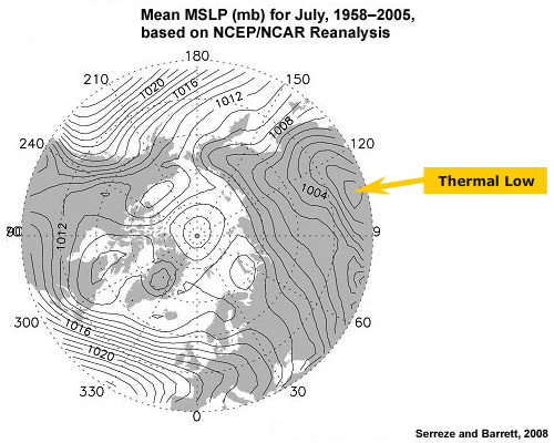
In summer, the Siberian High is replaced by a thermal low. The Aleutian and Icelandic Lows nearly disappear as the frequency of cyclones in the northern oceans drops considerably.
Arctic ClimatePolar Vortex
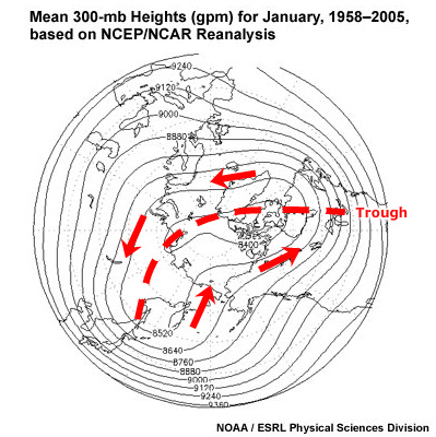
Heights of pressure surfaces are much lower in the Arctic than at mid latitudes. This results in a persistent large-scale, cyclonic circulation pattern in the middle and upper troposphere called the polar vortex. This feature is present over both the north and south poles. In the Arctic, the vortex is rather elongate with troughs over eastern North America and eastern Asia. As we have seen earlier, the polar vortex is not present at the surface; rather, it becomes a coherent feature only at about 500 mb and higher.
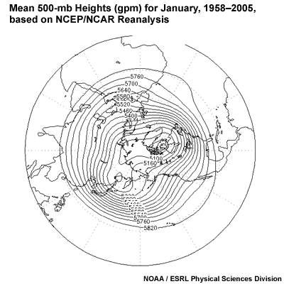
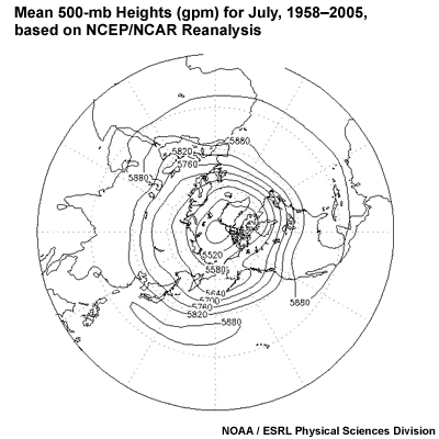
If we compare the winter and summer Arctic polar vortex, we can see that the vortex contracts and the gradient decreases significantly in the summer. This occurs due to warming of the Arctic, which causes the heights of pressure surfaces to rise.
Arctic ClimateTropopause

Generally speaking, in the Arctic, the tropopause (the level at which the fall of temperature with height ceases) is lower than in the tropics. The height of the tropopause varies seasonally in the Arctic from 8000 m in January to over 10,000 m in July. These soundings come from Franz Josef Land in the high Arctic (80N). The tropopause on 5 January was at about 310 mb or 8300 m. On 11 June, it was about 240 mb or 10,500 m.

Compare the Arctic soundings to these from San Juan, Puerto Rico (18N) for similar dates. In both January and July, the tropopause was near or above the 100-mb level at over 15 km.


If we look at maps of the height of the tropopause, we see a strong gradient in the mid latitudes that shifts north in the summer and south in the winter. This gradient marks the location of the polar jet.
As a result of the lower tropopause, clouds and storms are generally lower in the Arctic than at mid latitudes. In winter even intense cyclones are usually confined to altitudes below 15,000 ft (4600 m). The rare thunderstorm may be capped at a similar level.
Arctic ClimateSeasonal Temperatures
On land, temperatures in the Arctic are highly variable. Outside of glaciated areas, snow cover is quite thin and melts early in summer. This allows land to warm considerably under the continuous daylight. However, under the continuous darkness of winter, land cools and temperatures can become bitterly cold.
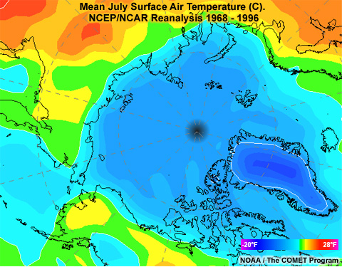
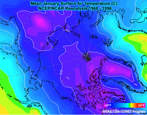
Over the ocean, summer temperatures are strongly moderated by open water and sea ice, which have summer temperatures near 0°C. In the winter, the water in the Arctic Ocean below the polar ice pack is never colder than -2°C (28°F). This moderates the overall climate and helps keep Arctic winters warmer than those in Antarctica.
The coldest winter temperatures typically occur in northern Asia, while the warmest winter temperatures are found where the North Atlantic Drift, the eastward extension of the warm Gulf Stream, flows up into the Norwegian and Barents Seas.
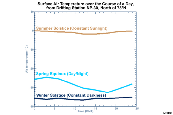
Continuous daylight in summer and darkness in winter lead to temperatures without a diurnal cycle of daytime warming and nighttime cooling. In winter, clear skies lead to strong radiational cooling and the formation of pronounced inversions. Temperatures rise when winds are strong enough to mix out the inversion and bring warmer air aloft down to the surface. Cyclones bring not only high winds that mix out the inversion, but also draw warmer, moister air from lower latitudes.
Arctic ClimatePrecipitation

Precipitation amounts in the Arctic vary widely. Where the warm North Atlantic Current passes Greenland and enters the Norwegian and Barents Seas, precipitation ranges from 400 to over 1000 mm/yr (16-40 inches). Over the Beaufort Sea and Northern Greenland, precipitation averages as little as 150 mm/yr (6 inches). The rest of the Arctic falls between these extremes with continental areas being wetter than oceanic areas.
In winter, away from the open waters of the North Atlantic, there is little moisture available for precipitation. Snow and ice cover combined with cold temperatures keep humidity low. As a result, heavy snowfall is not common in the Arctic and exceptionally heavy snowfalls are restricted to mountainous and maritime areas.
Arctic ClimateWind
In winter, surface wind speeds tend to be lower than one might expect given the paucity of trees and mountains. This occurs because the inversion that dominates winter weather decouples the surface wind from stronger winds aloft. Also coastal temperature gradients are weaker in the winter than summer, due to the presence of sea ice rather than open water.
In summer, inversions are less frequent and weaker. Furthermore, long days melt sea ice and warm the land, which increases the temperature contrast across coastal zones. This leads to more frequent cyclones and higher coastal winds. As a result, surface winds increase in the summer.
Arctic ClimateClouds
Clear skies over the Arctic in the summer are a rare occurrence. Abundant moisture trapped by a low-level inversion leads to frequent fog and low stratus. From about mid-June to mid-September, ocean areas are shrouded by fog or clouds 80 to 90 percent of the time.
In winter, frequent cyclones associated with the Icelandic or Aleutian Lows keep those areas relatively cloud covered. Areas with persistent high pressure over northern Asia and North America tend to be cloud free.
Arctic ClimateQuestions
Question 1
Which of the following are features of the winter MSLP field in the Arctic? (Choose all that apply.)
The correct answers are a) "Aleutian Low" and c) "Icelandic Low."
The Aleutian and Icelandic Lows result from the frequent occurrence of cyclones in these areas, fueled by warm currents and high temperature gradients. The Asian Low is a thermal low that occurs in the summer. In the winter it is replaced by the Asian High. The Polar Vortex is a feature that occurs aloft, typically at levels above 500 mb.
Question 2
Which of the following are characteristics of the Polar Vortex? (Choose all that apply.)
The correct answers are a) "Cyclonic circulation" and b) "middle and upper troposphere."
Due to extreme cooling near the surface, the Polar Vortex is stronger in winter, not summer.
Question 3
How high is the winter Arctic Tropopause? (Choose the best answer.)
The correct answer is b) "5000-10,000 m."
This is much lower than the height of the Tropopause in the tropics, which is frequently higher than 15,000 m.
Question 4
In winter, which of the following contribute to low surface temperature in the Arctic? (Choose all that apply.)
The correct answers are a) "clear skies" and c) "strong inversions."
Question 5
Where is the greatest average annual precipitation in the Arctic? (Choose the best answer.)
The correct answer is c) "Norwegian and Barents Seas."
The warm North Atlantic Drift flows into the Arctic through the Norwegian and Barents Seas. This current provides warmth and moisture to the atmosphere, which results in greater precipitation.
Question 6
When are suface winds generally stronger? (Choose the best answer.)
The correct answer is a) "summer."
In the winter, the strong surface inversion decouples surface winds from stronger winds aloft. Typically resulting in light winds at the surface. Also, temperature gradients increase in the summer as land warms, resulting in stronger winds, particularly near the coast.
Arctic ClimateReferences
Legates, D., and C. Willmott, 1990: Mean seasonal and spatial variability in gauge-corrected global precipitation. Int. J. Climatol., 10, 110–127.
NATO Naval Arctic Manual
http://publicintelligence.info/NATO-ArcticManual.pdf
Serreze, Mark C., Ciaran M. Hurst, 2000: Representation of mean Arctic precipitation from NCEP–NCAR and ERA reanalyses. J. Climate, 13, 182–201.