When to Observe
Because the weather has so far been calm this morning, your focus has been on routine observations, or METARs.
In general, there are three types of observations you will take:
- Routine Observations (METARs)
- Special Observations (SPECIs)
- Local Observations (LOCAL)
Routine observations are taken and reported hourly. Required elements are observed within the 15 minutes preceding the hour. When in port, a ship should continue regular observing and reporting unless there is a nearby U.S. manned weather reporting activity meeting the requirements. Your METARs will need to be reported between 5 minutes and 1 minute before the hour, so for a 1400Z observation, you will submit your data between 1355Z and 1359Z.
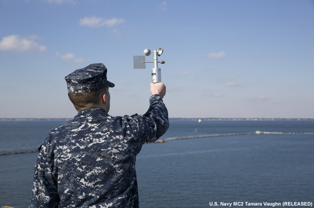
AG2 Ferguson gives you guidance for taking your METAR.

AG2 Ferguson: "When taking a weather observation you need to start 15 minutes prior to observation time, as it will take about 10 minutes to take your observation. Where to take your observation depends on your platform on a large ship like this, you want to take it next to the bridge. On a small ship, such as a frigate, you'd take it on a bridge wing. When taking an observation, you want to start at the surface and work your way up. So you'd start with the seas, then move to visibility, then low clouds, mid clouds and high clouds. OK, let's get started."
If conditions warrant, you will also need to take special observations (SPECIs) to report significant changes in weather elements affecting aircraft or ship operations. SPECIs are also taken to record the weather conditions at the time of any significant event, including an aircraft mishap, collision at sea, or man overboard. SPECI observation criteria include:
- changes in ceiling that cross 3000-feet, 1500-feet, 1000-feet, and 500-feet thresholds, or the lowest standard instrument approach minimum as published
- development of clouds or obstructions aloft at altitudes below 1000 feet
- changes in visibility across 3-mile, 2-mile, and 1-mile thresholds, or the lowest standard instrument approach minimum as published
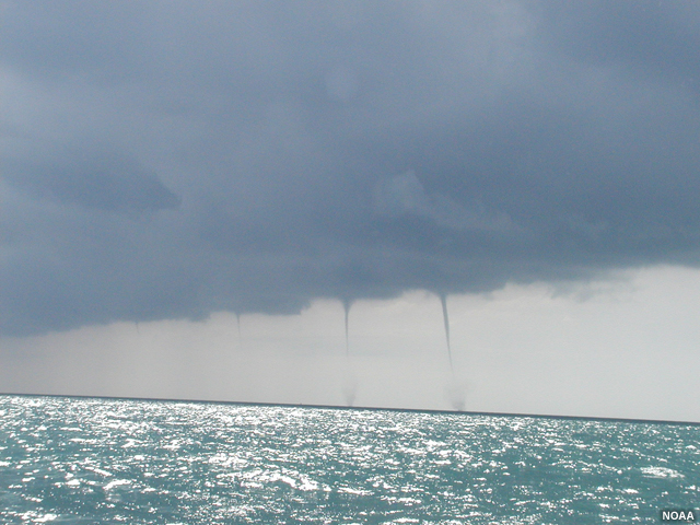
- a tornado, funnel cloud, or water spout observed or disappearing from sight
- the first occurrence of thunder is heard, or if thunder cannot be heard directly because of flight deck noise, at the first sight of lightning
- an aircraft mishap
- wind direction changes of 45 degrees or more in less than 15 minutes when the sustained wind speed is 10 kts or more
- beginning or ending of hail ¾ inch or greater, beginning, ending, or change in intensity of freezing precipitation or ice pellets
- squalls
- a volcanic eruption
- any other meteorological situation that is critical to the safety of aircraft operations
Today, you know that there is a chance of thunderstorms, which can bring visibility issues, lowered ceilings, squalls and shifting winds, lightning, and other hazards, particularly for any aviation operations in progress on the ship. If thunderstorm or other significant weather conditions begin to materialize, you will want to make sure to do the SPECIs and document the weather changes.

In addition to METARs and SPECIs, your reporting will include synoptic observations, which are recorded at the standard synoptic hours of 0000Z, 0600Z, 1200Z, and 1800Z. Additional synoptic reports are filed at 0300Z, 0900Z, 1500Z, and 2100Z per applicable fleet operation hours or at the discretion of the unit when unusual or significant weather phenomena are encountered.
Local observations are taken at the discretion of the individual METOC teams as operations and conditions warrant. These can include half-hourly observations during flight operations, strait transits, or other weather-sensitive activities.