Cloud Type and Height
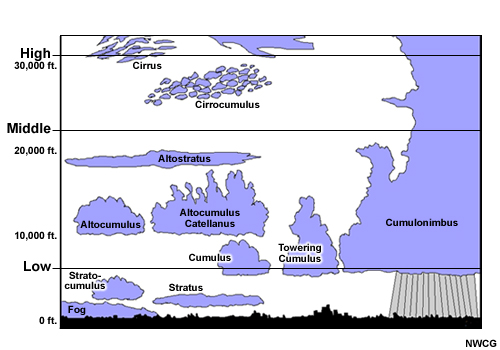
Clouds are classified as either low, middle, or high, based on height. They are generally of two types, stratiform or cumuliform, with minor exceptions.
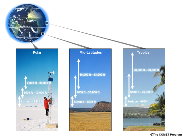
Having an idea of the typical low, middle, and high cloud heights for the part of the world you are in will help you in making your estimates. For instance, mid-level clouds near the equator generally have heights between 6500 feet and 26,000 feet, while nearer the poles, these cloud heights are likely to be in 6500-13,000 feet range.
AG2 Ferguson gives you some tips for determining cloud type and height.

AG2 Ferguson: "When taking a weather observation, you need to ensure that you have a clean line of sight. Once you have a clear line of sight, you can evaluate the clouds that you have. Is it a cumuliform cloud, where it's puffy and cotton-like, or do you have a stratiform cloud, a more uniform, sheet-like cloud, or is it cirrus - a thin, wispy, hair-like cloud? Next, you need to identify the cloud heights. Today we have low cumulus clouds. A low cloud is anything below sixty-five hundred feet. Generally, cumulus clouds form at about three thousand feet. You can identify your accuracy of height based on pireps and local observations, to ensure that your heights are accurate. Next, you move to your mid-clouds. Mid-level clouds are between sixty-five hundred and twenty-three thousand feet. Generally, they develop at the ten thousand feet mark. Next you identify your high clouds. High cloud levels are from sixteen thousand feet to fifty thousand feet. They generally form at the twenty thousand foot mark. High clouds are composed of ice crystals, and are generally thin, wispy, light clouds."
Meteorologists classify clouds according to their height and physical structure. Here's a summary of common cloud descriptors and their meanings.
| Root | Meaning |
|---|---|
| cirro- | high |
| alto- | mid |
| strato- | layer |
| cumulo- | heap |
| nimbo- | rain, precipitation |
Cloud names are derived from the Latin roots listed in the table. For example, a layered cloud producing rain would be named nimbostratus and a high cloud appearing in heaps would be called cirrocumulus.
| Low 0-8000 ft |
Middle 6,500-20,000 ft |
High 16,000-50,000 ft |
|
|---|---|---|---|
| Stratiform | Stratus Stratocumulus (surface to 6500 ft) |
Altostratus (~8000-20,000 ft) Nimbostratus (~6500-8000 ft) |
Cirrostratus (>20,000 ft) |
| Cumuliform | Cumulus Cumulonimbus Stratocumulus (typically <6500 ft) |
Altocumulus (~18,000-24,000 ft) | Cirrocumulus (~25,000 ft) |
| Other | Cirrus (>25,000 ft) |
Once you have identified the type of cloud as stratiform (layered) or a cumuliform (heaped), you can determine whether it is low, mid (alto), or high (cirro). From there gauge the cloud base height based on climatology for your area.