Arctic CyclonesPolar Lows
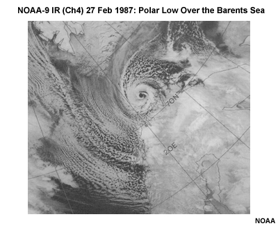
Winter cyclones that form in polar air masses over open water are called Polar Lows. These cyclones are small, typically several hundred kilometers in diameter, and frequently display an "eye", much like a tropical cyclone. For this reason, they have been called "Arctic Hurricanes" or "Polarcanes." They form where frigid Arctic air flows over a body of warmer water, which results in a strong flux of heat and moisture from sea to atmosphere. This destabilizes the lower atmosphere. When coupled with support of a cold upper-level trough, they quickly intensify, reaching their maximum strength within 12 to 24 hours. Fueled by the warmth and moisture of open water, polar lows dissipate quickly once they move over land or sea ice. Given their small size and the paucity of observations in the Arctic, numerical weather prediction models have a difficult time predicting these cyclones. Forecasters need to look at the synoptic conditions combined with satellite imagery to make a solid forecast.