Encoding Section 1 Synoptic Observations
In Section 1, you should encode the various reporting groups based on your observations of the meteorological conditions. Here is a summary of those groups and the included parameters.
Section 1
The first group of Section 1 contains columns for reporting precipitation, a weather data indicator, lowest cloud height, and visibility. The next set of columns is where total cloud amount, wind direction, speed, and wind gusts are reported.
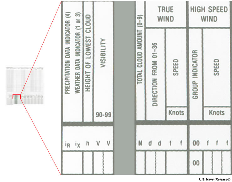
Here is a brief summary of the first Section 1 fields to be completed:
- Precipitation Data Indicator, iR
iR is always reported as 4 and indicates that no precipitation data are included since ships do not measure precipitation amounts. - Weather Data Indicator, ix
ix is the code figure indicating the presence of weather phenomena data in the observation (see Table III-3-1). - Height of lowest cloud, h
h is the height of the base of the lowest cloud layer observed (see Table III-3-2). Example: if the lowest cloud base is around 1500 ft, encode column h as 4 based on Table III-3-2. - Prevailing visibility, vv
vv is the prevailing visibility observed, including all sector visibilities (Table III-3-3). Example: If the visibility is 5 nm, encode vv as 97 based on Table III-3-3.
- Total cloud amount, N
N is the total cloud amount from 0-9 from Table III-3-4. Example: If the total cloud cover is 5/8ths, encode it as 5 based on Table III-3-4. - True wind direction, dd
dd is the hundreds and tens of the direction the wind is blowing (for calm, use 00). Example: If the wind is blowing from the south, encode dd as 18. - True wind speed, ff
ff is the true wind speed in knots.
Section 1, Groups 1, 2, 4, and 5
Groups 1 and 2 provide fields for entering temperature data for your synoptic observation. Pressure data are recorded in Groups 4 and 5.
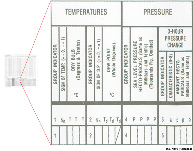
Here is a brief listing of the reported parameters:
Section 1, Groups 1 and 2
- Dry bulb temperature, snTTT
sn indicates the sign of the dry bulb temperature: “0” if the temperature is positive, “1” if it is negative; TTT is the ambient air temperature in tens, units, and tenths degrees Celsius. Example: A dry bulb temperature of 19.5 °C is encoded as 0195. - Dewpoint temperature, snTdTdTd
sn indicates the sign of the dewpoint temperature: “0” if the temperature is positive, “1” if it is negative; TdTdTd is the dewpoint temperature in tens and units degrees Celsius, followed by character /. Example: If the dewpoint temperature is 2.3 °C, encode it as 002.
Section 1, Group 4
- Sea level pressure, PPPP
PPPP is sea level pressure in hundreds, tens, units, and tenths of hectopascals. Example: If the sea level pressure is 992.25, encode it as 9923.
Section 1, Group 5
- 3-hr pressure change, appp
a is the code indicating the characteristic of pressure tendency (see Table III-3-5); ppp is the change in pressure in tens, units, and tenths of a hectopascal, reported only for ships anchored or moored for a full three hour period.
Section 1, Groups 7, 8, and 9
Present and past weather are encoded in Group 7. Group 8 provides columns for reporting cloud amount and type.
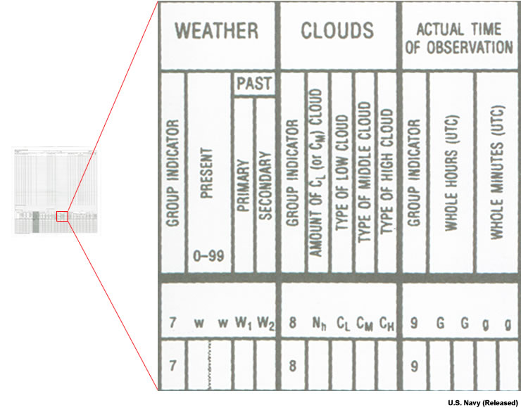
Here is a brief summary of the columns for encoding Group 7, 8, and 9 data:
Section 1, Group 7
- Present weather, ww
ww is the present weather code (0 to 99) based on Table III-3-6. Example: Continuous heavy rain falling at the time of the observation is encoded as 65. - Past primary and secondary weather, W1W2
W1W2 corresponds to the primary and secondary past weather in order of priority as defined in Table III-3-7. Example: If the weather occurring in the last few hours was drizzle under overcast skies, W1W2 should be encoded as 5, 2 based on Table III-3-7.
Section 1, Group 8
- Low cloud amount, Nh
Nh is the amount of low clouds present CL, or mid clouds if there are no low clouds (Table III-3-4). - Low cloud type, CL
CL is the code figure representing predominant type of low cloud present (Table III-3-8). Example: If cumulus clouds are spreading out and no cumulonimbus cloud is present, CL is encoded as 4 based on Table III-3-8. - Mid cloud type, CM
CM is the code figure representing predominant type of mid cloud present (Table III-3-9). Example: If altocumulus clouds are present on several levels in a generally chaotic sky, encode CM as 9 based on Table III-3-9. - High cloud type, CH
CH is the code figure representing predominant type of high cloud present (Table III-3-10). Example: If cirrocumulus clouds are present and predominant over other clouds, encode CH type as 9.
Section 1, Group 9
Group 9 provides fields for entering the time of the synoptic observation.
- Observation time, GGgg
GG is the observation hour in whole hours UTC; gg is the observation minute in whole minutes UTC