Table of Contents
Geography
GeographyWhat is the Arctic?
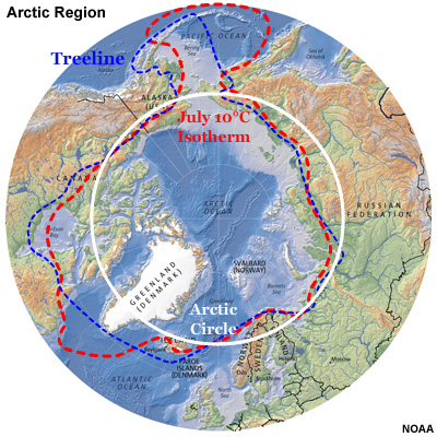
The Arctic is generally considered to be the area north of the Arctic Circle (66°32'N) —the latitude above which the sun doesn't rise on winter solstice or set on summer solstice.
It is alternatively defined as the area having average daily summer temperatures colder than 10°C or the area north of treeline, marked by tundra. Tundra lacks permanent snow-ice cover and is mostly underlain by permafrost.
GeographyLand Areas
Most of the population of the eight "Arctic" countries—Russia, the U.S., Canada, Denmark, Iceland, Norway, Sweden, and Finland—actually lives in the area considered subArctic by physical geography definitions. These countries, with the exception of Sweden and Finland, border the Arctic Ocean.
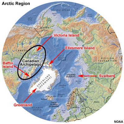
Major islands in the Arctic include Greenland, Svalbard, and the vast Canadian Archipelago, including Baffin, Ellesmere, and Victoria Islands. Several other island groups lie on the continental shelf north of Eurasia.
GeographyGlaciers
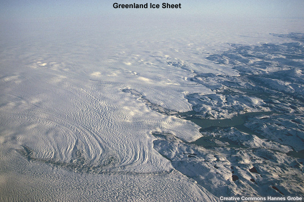
Glacial ice is largely confined to the Greenland Ice Sheet. This ice sheet is about four times larger than the combined areas of the glaciers and ice caps of the rest of the Arctic.
GeographyTopographic Features
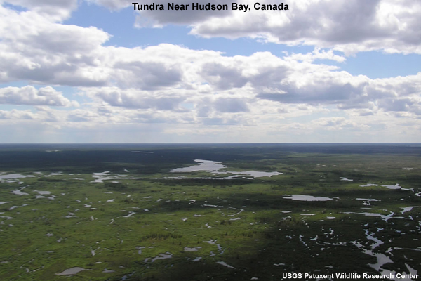
Much of the Arctic coastline is marked by broad, flat tundra, which means the wind blows nearly continuously because the flow is largely unobstructed. The West Siberian Plain and Central Siberian Upland cover a large part of the Russian Arctic and are primarily tundra.
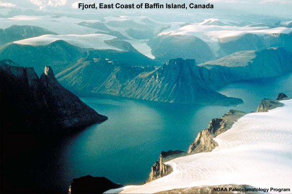
However, some areas are marked by well-defined topography, including the sea cliffs and deeply incised fjords of Norway, Greenland, and the Canadian Arctic Archipelago.
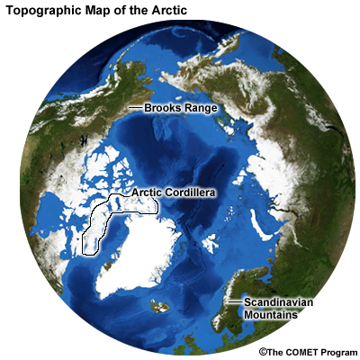
Prominent mountain ranges include the Brooks Range of Alaska, the Arctic Cordillera of Canada, and the Scandinavian Mountains. The summit of the Greenland ice sheet reaches over 3000 m (~10,000 ft).
GeographyNavigation
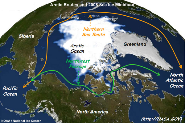
Maritime operations in the Arctic have historically been constrained by weather and sea ice. As more Arctic waters remain ice-free through greater durations of the year, operations are increasing. In 2008, the Northwest Passage through the Canadian Arctic Archipelago and the Northern Sea Route along the Eurasia coast became navigable due to a dramatic reduction in pack ice.
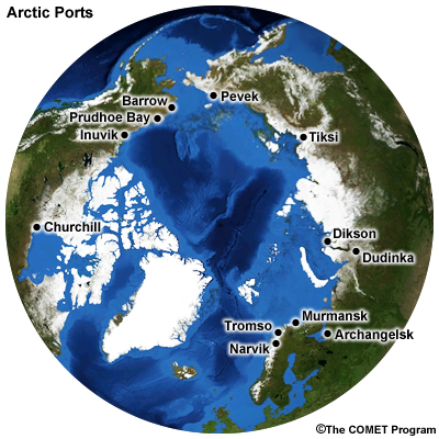
Currently, the Arctic region is served by a number of port areas, as shown on this map. These ports are typically separated by large distances.
GeographyOcean and Seas
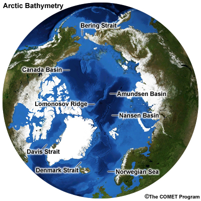
The Arctic Ocean is divided into several basins by a series of parallel ridges, the most prominent of which is the Lomonosov Ridge. The Canada Basin dominates the North American side, while the Amundsen and Nansen Basins underlie the Eurasian side.
The U.S. and Canadian side of the Arctic Ocean is marked by a narrow continental shelf extending 100 to 200 kilometers offshore, while on the Russian side the continental shelf is very broad, extending about 1200 km (~700 mi) off the Siberian coast. Off the continental shelf, the Arctic Ocean averages 3700 meters depth. Several marginal seas ring the Arctic Ocean, including the Bering, Beaufort, Chukchi, Barents, and other seas.
Nautical access to the Arctic Ocean is limited to the Bering Strait (AK-Russia), Davis Strait (Canada-Greenland), Denmark Strait (Greenland-Iceland), and the Norwegian Sea (Iceland-Norway).
GeographyQuestions
Question 1
Which of the following constitutes a definition of "Arctic"? (Choose all that apply.)
The correct answers are a), b), and c).
Answer d) is incorrect as sea ice commonly occurs outside of areas defined as Arctic, including the Bering Sea, Sea of Ohkotsk, and Hudson Bay.
Question 2
Which one of the following countries does not border the Arctic Ocean? (Choose the best answer.)
The correct answer is b) "Finland."
While Finland is an Arctic Country, its northern border touches on Russia and Norway, not the Arctic Ocean.
Question 3
In which Arctic country is the vast majority of glacial ice located? (Choose the best answer.)
The correct answer is b) "Denmark (Greenland.)"
Over 80% of Arctic glacial ice is found in the Greenland Ice Sheet.
Question 4
Which shipping route traverses the coast of Eurasia? (Choose the best answer.)
The correct answer is b) "Northern Sea Route."
The Northwest Passage traverses the coast of Alaska and the Canadian Arctic Archipelago. There is no Northeast Sea Route.
Question 5
[True/False] Due to sea ice, Russia has no ports on the Arctic coast
The correct answer is False.
Russia has several sea ports on the Arctic Ocean. However, up until now, most of them open for only brief periods in the summer and are separated by large distances.
Question 6
Use the selection boxes to choose the answers that best complete the statements.
The correct answer is that the continental shelf along the Russian coast is wide, while the shelf along the Alaska coast is narrow.
GeographyReferences
Arctic Marine Geography, Climate, and Sea Ice http://www.arctic.gov/publications/AMSA/arctic_marine_geography.pdf
Glaciers and Ice Sheets in the Arctic http://www.eoearth.org/article/Glaciers_and_ice_sheets_in_the_Arctic
NATO Naval Arctic Manual
http://publicintelligence.info/NATO-ArcticManual.pdf