Table of Contents
Arctic Cyclones
Arctic CyclonesIntroduction
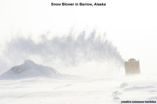
Cyclones in the Arctic present a significant forecast challenge, bringing precipitation, high winds, and high seas. Cyclones can also lead to warming, by either bringing warm air from the south or by mixing out the wintertime inversion. Visibility is reduced when warm, moist air is advected over cold SSTs or sea ice, resulting in extensive fog or low stratus. Cyclone-induced strong winds can lead to blowing snow, which also reduces visibility.
Arctic CyclonesClimatology - Winter
The formation and intensification of cyclones is associated with strong temperature gradients. In the Arctic, these gradients typically form near the boundaries of open water.
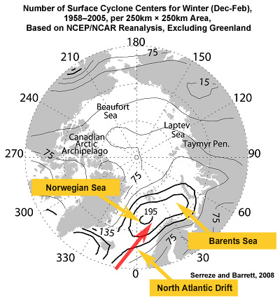
This graphic shows the number of cyclones detected in winter per 250km x 250km area over the 47-year period of 19582005. In the winter, cyclones mostly occur over the warm North Atlantic drift that flows up into the Norwegian and Barents Seas, which correlates well with the Icelandic Low.
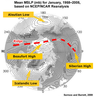
Storms in the North Pacific, associated with the Aleutian Low, are typically blocked from entering the Arctic by the surface ridge that extends from Siberia, across the Arctic Ocean, to northwest Canada. Instead, these storms tend to track into the Gulf of Alaska.
Cyclones that form over Eurasia or North America tend to be steered to the southeast by upper level winds. Few storms form or intensify over winter sea ice, though storms may drift over the ice and dissipate.
Arctic CyclonesClimatology Summer
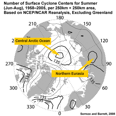
In summer, storms occur most frequently over the central Arctic Ocean. These storms tend to originate either over northern Eurasia, where we see a concentration of storms, or along the Eurasian coast, where there is a strong temperature contrast in the summer months.
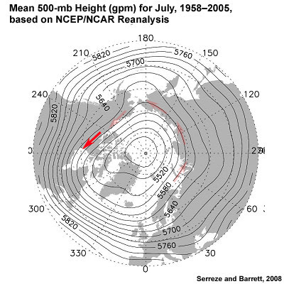
Winds at 500 mb tend to steer storms parallel to the coast across Eurasia and Alaska. Storms that originate over North America tend to move southeast, away from the Arctic.
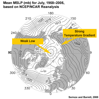
In contrast to winter, summer MSLP over the Arctic shows a strong gradient along the Eurasian coast. The rest of the field is fairly flat with a weak low located near the North Pole, reflecting the frequent occurrence of cyclones in this region.
Arctic CyclonesFormation of Summer Cyclones
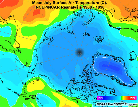
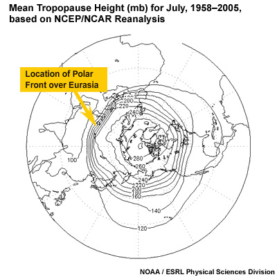
When spring arrives and daylight returns to the Arctic, the thin snow cover quickly melts from land. With snow gone, land warms quickly. The sea ice covering the ocean melts slowly, keeping ocean temperatures cool. As a result, there is a strong temperature gradient along the coast, as seen here, resulting in a stationary front. The coastline in the Arctic runs east-west from Western Russia, all the way east to the Canadian Archipelago. As a result, the stationary front separates large reservoirs of cold air to the north from warm air to the south.
Most of the summer cyclones in the Arctic originate in two places: (1) along the Polar Front over land in northern Eurasia or (2) as tropospheric waves ripple along the coastal front. As these disturbances migrate along or over the coast, they induce warm offshore flow. The warm air evaporates water from the melting sea ice, destabilizing the lower atmosphere and generating or enhancing low pressure. On the backside of the low, cold dry air off the polar ice cap is drawn in, enhancing the lift along the surface frontal boundary.
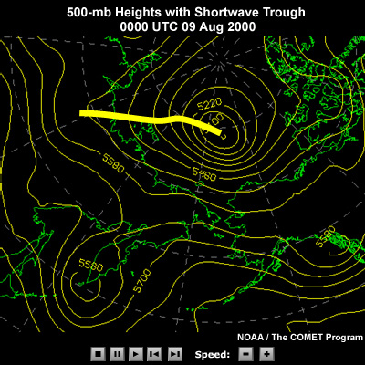
Meanwhile, aloft, a series of long waves and short waves migrates in an easterly direction around the Polar Vortex, like we see in our scenario case. As these long waves and short waves sweep along the east-west coast line, their troughs and ridges alternately generate lift or subsidence. Cyclones are triggered when the lift from a trough aloft comes into phase with a surface low along the coast. The resulting cyclone now tracks parallel to the coast, steered by winds aloft. The cyclone can strengthen, even deepen explosively, in response to the interaction of cold Arctic air to the north and warm continental air to the south as upper level winds drive the low on an ENE trajectory.
The Arctic is a data sparse region, so numerical models can miss the explosive deepening of a cyclone. A solid understanding of models, their limitations, and extensive use of satellite data is the only way to produce a consistent, accurate forecast.
Arctic CyclonesPolar Lows
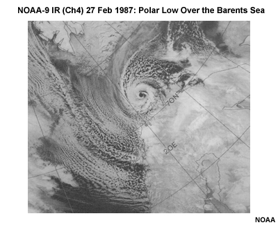
Winter cyclones that form in polar air masses over open water are called Polar Lows. These cyclones are small, typically several hundred kilometers in diameter, and frequently display an "eye", much like a tropical cyclone. For this reason, they have been called "Arctic Hurricanes" or "Polarcanes." They form where frigid Arctic air flows over a body of warmer water, which results in a strong flux of heat and moisture from sea to atmosphere. This destabilizes the lower atmosphere. When coupled with support of a cold upper-level trough, they quickly intensify, reaching their maximum strength within 12 to 24 hours. Fueled by the warmth and moisture of open water, polar lows dissipate quickly once they move over land or sea ice. Given their small size and the paucity of observations in the Arctic, numerical weather prediction models have a difficult time predicting these cyclones. Forecasters need to look at the synoptic conditions combined with satellite imagery to make a solid forecast.
Arctic CyclonesQuestions
Question 1
[True/False] The occurrence of Arctic cyclones correlates well with strong surface temperature gradients.
The correct answer is True.
Question 2
Use the selection boxes to choose the answers that best complete the statements.
The correct answer is the maximum occurrence of Arctic cyclones in winter occurs over the Norwegian Sea, while the summer maximum occurs over the North Pole.
Question 3
In the winter, cyclones that form over Eurasia tend to be steered in which direction? (Choose the best answer.)
The correct answer is c) "to the southeast."
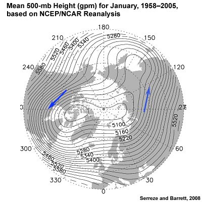
500 mb heights over the Arctic show a large trough from the North Pole to Japan, which tends to steer cyclones to the southeast over Eurasia.
Question 4
In the summer, cyclones that form over Eurasia tend to be steered in which direction? (Choose the best answer.)
The correct answer is a) "to the East."
500-mb heights over the Arctic show have contours that run east-west. This takes cyclone parallel to the coast, tracking the strong temperature gradient there.
Question 5
Where do Polar Lows develop? (Choose the best answer.)
The correct answer is c) "Over water."
Polar Lows form where frigid Arctic air flows over a body of warmer water, which results in a strong flux of heat and moisture from sea to atmosphere, which destabilizes the lower atmosphere.
Arctic CyclonesReferences
Serreze, M. C., and Barrett, A. P., 2008: The summer cyclone maximum over the central Arctic Ocean. J. Climate, 21, 1048–1065.
COMET module: Polar Lows: Ungava Bay 01 December 2000