Table of Contents
Oceanography
OceanographyCurrents
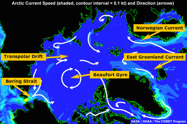
Ocean currents in the Arctic are generally weak, 0.5 kt or less. The Norwegian Current is the northeast extension of the Gulf Stream, and thus brings warm (6 - 8°C), saline water in to the Arctic. Surface currents flow into the Arctic along the Norwegian Current with a minor addition through the Bering Strait.
Within the Arctic basins, surface currents are dominated by 2 features: the anticyclonic Beaufort Gyre and the Transpolar Drift. These currents are weak, even by Arctic standards, because ice cover inhibits wind forcing. Along the continental shelf, close to shore, currents tend to flow west to east, but are strongly influenced by local bathymetry.
Currents exit the Arctic primarily along the East Greenland Current and also filter through the Canadian Archipelago. Surface water exiting the Arctic is fresher and quite cold (-1°C). One consequence of this temperature difference is that Norwegian ports at 70° latitude can be reached by sea during the entire year, while on the other side of the Atlantic, icebergs reach 40°N, south of the Newfoundland Bank.
OceanographySilled Basin
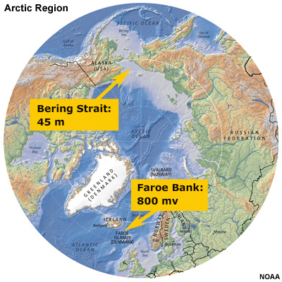
When we look below the surface, we see that the flow of water in and out of the Arctic is severely limited by the bathymetry. The Arctic Ocean is termed a “silled” basin because a submarine ridge separates the Arctic from the Atlantic. Between Canada and Scotland, the deepest channel is only 800 meters deep. The connection with the Pacific Ocean through Bering Strait is only 45 meters deep. As a result, there is no exchange of deep water between the Arctic and the rest of the world’s oceans.
OceanographyWater Masses
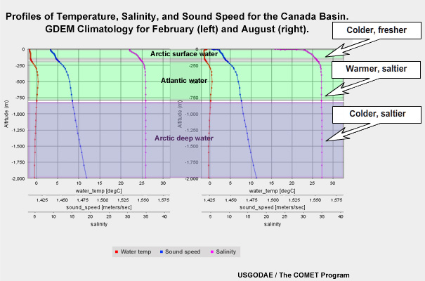
The geometry of the basin, combined with the inflow of Atlantic water, determines the profile of the water column. Arctic surface water (0-200 m) is relatively fresh due to runoff from many large rivers draining Siberia and Northern Canada. Below this fresh layer is a layer of Atlantic water (200-800 m), which is both warmer and saltier. Below the Atlantic water is Arctic deep water, as cold as the surface water and as salty as the Atlantic water. This has pooled in the deep basin.
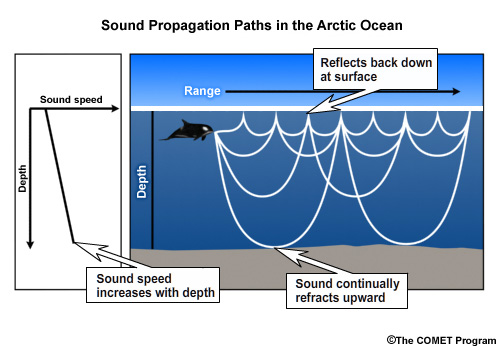
Operationally, this vertical profile of the water column has little effect on surface vessels, but may affect submarine operations. Unlike most of the world ocean, sound speed increases with depth from the surface to the seafloor. Sound continually refracts upward toward slower speeds at the surface, where it reflects back down. As a result, sound travels a long way in the Arctic with few “blind spots.”
OceanographyQuestions
Question 1
Which of the following is a characteristic of currents in the Arctic Ocean? (Choose all that apply.)
The only correct answer is b) "Generally weak (speed <0.5kt)."
Currents tend to flow west to east along the coasts of Eurasia and North America. Surface currents tend to flow into the Arctic through the Bering Strait and Norwegian Current.
Question 2
How deep is the sill that separates the Arctic Ocean from the North Atlantic? (Choose the best answer.)
The correct answer is c) "800 meters."
As a result, there is no exchange of deep water between the Arctic and the rest of the world ocean.
Question 3
Use the selection boxes to choose the answers that best complete the statements.
The correct answer is that Atlantic water in the Arctic Ocean is warmer and saltier than Arctic water.
Question 4
Due to the sound speed profile, which direction do sound waves in the Arctic Ocean typically refract? (Choose the best answer.)
The correct answer is b) "Upwards."
Because sound speed tends to increase with depth, sound waves continually refract upwards in the Arctic Ocean.